Whats new in version 3.7.2.8307:
- New feature: Knots - HoudahGeo can now display speed in knots (nautical mile / hour)
- Enhancement: Image loading - HoudahGeo now checks if it has read privileges before trying to load an image file
- Enhancement: Paste Coordinates - Pasting coordinates now understands more number formats and separators
- Bug fix: Appearance - Fixes display glitches when resizing the window
Publisher review:HoudahGeo is a utility for Mac that allows you to easily geotag your photos.
The software is compatible with the tools the likes of Google Earth or Flickr and can use metadata to automatically place your images or you want. It takes into formats support EXIF, IPTC or XMP. The module will also give you the ability to track all your images on a support GPS fit!
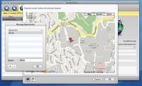
HoudahGeo includes several modes for adding geographical data to your images. HoudahGeo can match photos to a GPS track log or to reference photos that were taken using an iPhone. You can also set the location manually, using Google Earth or a map.
HoudahGeo can also attach pictures to GPS waypoints or to coordinates found on Google Earth, Wikipedia or any other website.
HoudahGeo is able to connect to many types of GPS track loggers and read GPX, NMEA, TES and TCX files.
Requirements:
- A digital camera.
- Optionally a GPS device.
Operating system:Mac OS X 10.6 or later